Landslide Geo-Information Services
Access the AppWhy?
Landslides are difficult to predict and still often to detect. They cause severe socio-economic constraints in mountainous regions and significant risks to people and infrastructures. These aspects call for sustainable land use planning with innovative mapping and modelling tools. eo4landslides aims to offer on-line services in order to exploit the full potential of satellite data coupled to advanced modeling for landslide hazards assessment in the mountain regions.
Observation
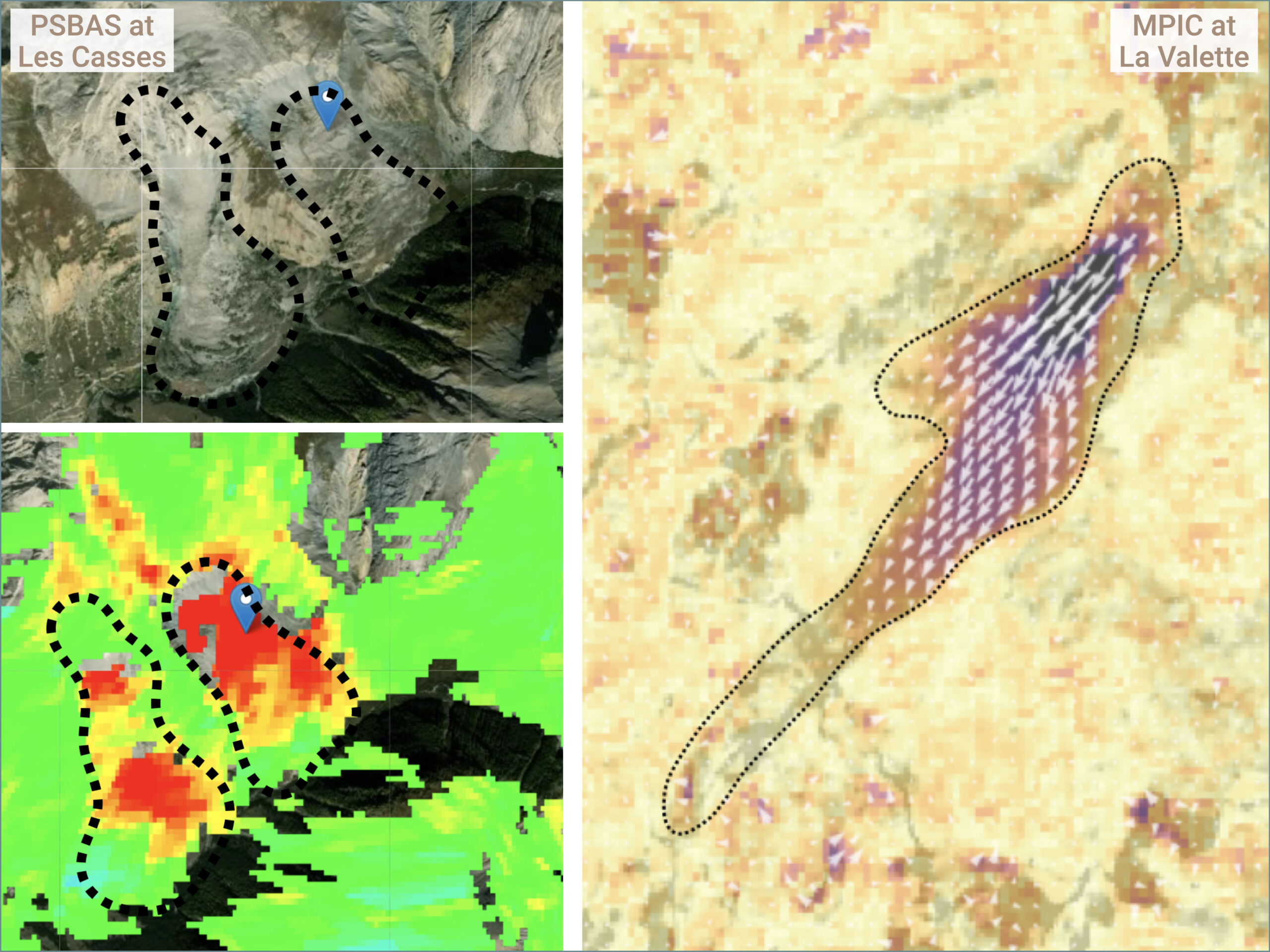
Radar and optical satellite images are increasingly used to support landslide risk management. Interferometry, offset-tracking and change detection methods applied to large volumes of images provide information on ground motion and landslide detection.
Modelling
Mapping terrain susceptibility and hazard to landslides is crucial for land use planning. This requires the construction of reliable landslide inventories, as exhaustive as possible, regularly updated, and providing advanced landslide descriptors.
Information sharing
Landslide products need to be shared between all Disaster Risk Management (DRM) actors, from scientists to private consultants and public authorities, involved at local, regional and national scales.
How?
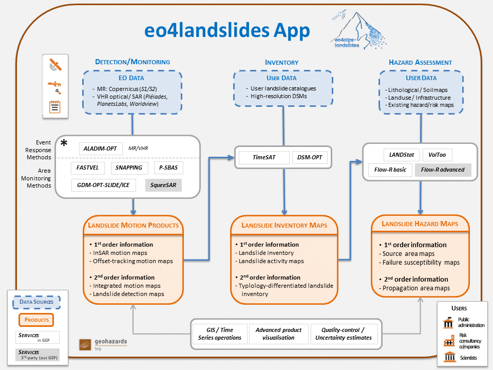
The quality of satellite-based Earth observation (EO) products has improved considerably in recent years. This, combined with relevant advanced models, supports the development of operational geo-information services and products for landslide risk assessment. eo4landslides integrates three types of interlinked services:
Landslide-Motion
This service is dedicated to the survey of unstable slopes in near-real time and in a systematic mode, and generates landslide ground motion products.
Landslide-Inventory
This service is dedicated to the creation and update of detailed catalogues of landslide events.
Landslide-Hazard
This service is dedicated to the forecast of spatial landslide hazard and landslide evolution scenarios.
eo4landslides is user-tailored and adapted to several scales:
User-driven
The services are user-driven with the engagement of many authorities and stakeholders responsible for landslide Disaster Risk Management.
Scales of analysis
The services are tailored for three analysis scales using specific data and models (Tier 1: regional/basin authority level; Tier 2: municipality level; Tier 3: slope specific level).
Interoperability
The services are accessible online and optimized for high performance computing. They are designed as generic as possible for application in other settings and interoperability with other information systems.
eo4landslides is accessible online on the Geohazards Exploitation Platform (GEP)
MoreWhat?
The services cover the key areas of interest to landslide practitioners, science and DRM communities seeking to better assess landslide hazard and risk.
A leaflet presenting and illustrating the online services available on eo4alps-landslides can be downloaded here.
Landslide-Motion
The module allows creating motion maps and time series using several sensors and image processors:
- InSAR motion maps from stacks of SAR satellite images through several baseline InSAR processors (SNAPPING med/full res., P-SBAS, Fastvel).
- Offset-tracking motion maps based on time-series of multiple optical image pairs (GDM-OPT-SLIDE).
- Landslide detection maps using pre- and post-event imagery from multi-source satellite sensors and/or aerial photographs (DSM-OPT, ALADIM-HR/VHR).
- Integrated motion maps from the combination of the various ground motion maps and change detection maps to create landslide feature maps (TimeSAT basic/advanced).
- Further the module allows accessing to third-party highly sophisticated processing software (TRE-Altamira SqueeSAR™) available at request on Fench, Swiss and Italian AOI.
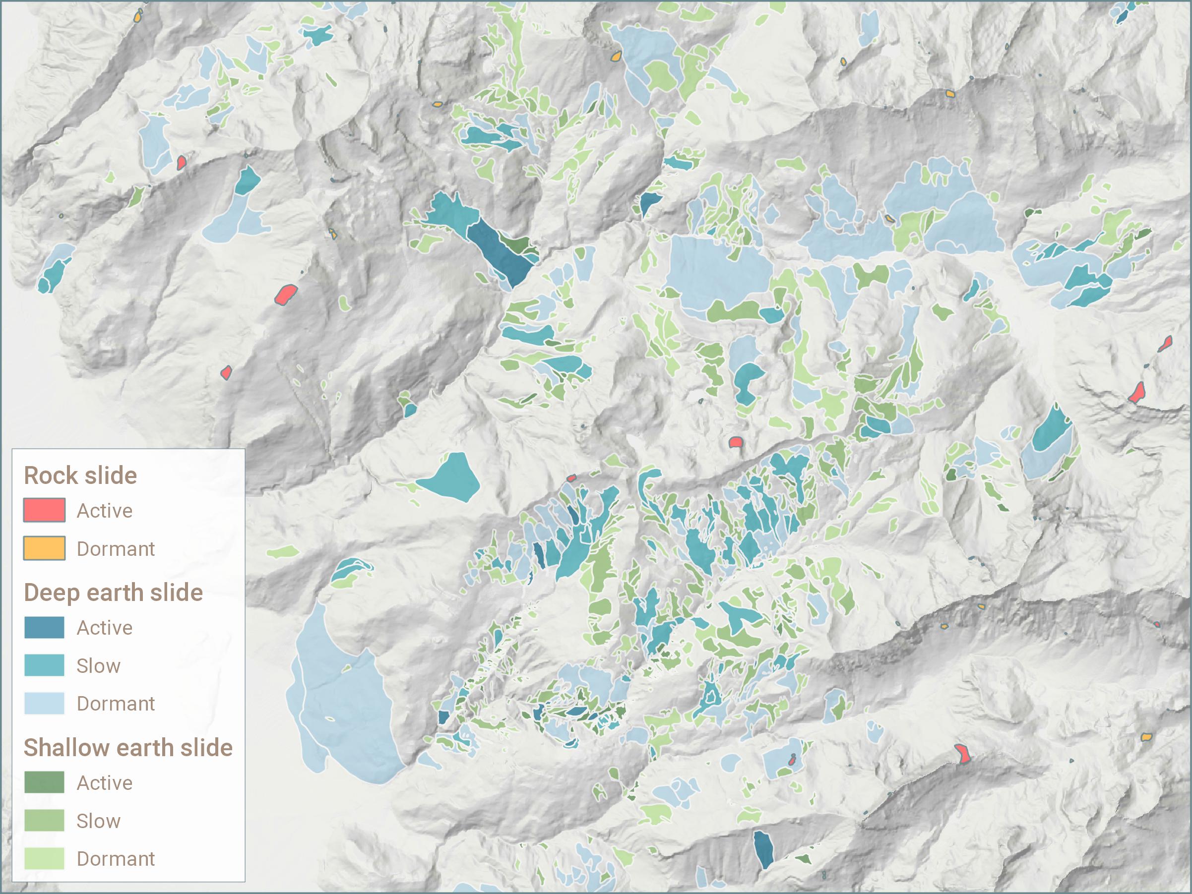
Landslide-Inventory
The module allows creating and updating landslide catalogues using several methods:
- Integrated motion maps combine various terrain motion maps and change detection maps to create landslide map features (TimeSAT basic/advanced).
- Landslide inventory maps from the fusion of integrated motion maps with existing landslide catalogues.
- Next, the module allows the visualization and updates of existing landslide inventories and access to GIS operations.
Landslide-Hazard
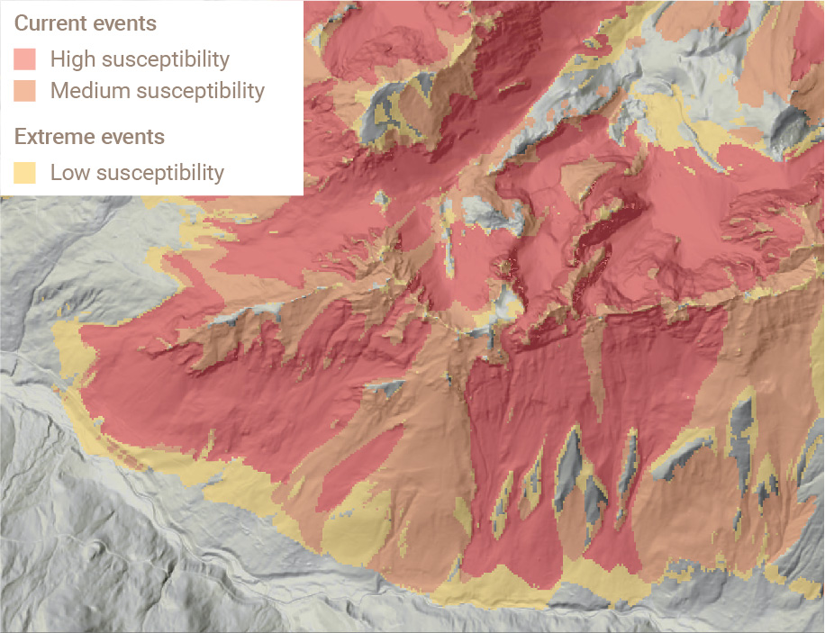
The module allows forecasting spatial landslide hazard and evolution scenarios using models with the identification of:
- Landslide source areas from the correlation of landslide inventories with predisposing and triggering factors (LAND-Stat in TimeSAT).
- Failure susceptibility maps by weighting predisposing and triggering factors of the landslide source areas (LAND-Stat in TimeSAT).
- Propagation area maps based on landslide type-specific run-out modelling (VolToo, Flow-R basic).
- Further, the module allows accessing to third-party highly sophisticated processing landslide softwares (Flow-R advanced, MIBSA) available at request through a system of quote.
System Concept
The founding eo4alps-landslides focused on pilot areas in the French, Swiss and Italian Alps
Who?
The eo4landslide app was developed during the eo4alps-landslides project (2021-2023), part of the Alpine regional scientific initiative funded by the European Space Agency and led by an international group of experts.
Partnership
The partners are landslide science experts, consulting companies in geological risks, InSAR processing and IT, and geological surveys.
Leading experts
The consortium is led by Dr Jean-Philippe Malet with the support of Dr Clément Michoud.
ESA regional initiatives
The European Space Agency has impulsed several regional initiatives to promote and foster the use of satellite data in society.
The Alps initiative (eo4alps) is sponsoring actions on snow, glaciers, air quality, ecosystems, and, in this case, landslides.
FAQ
Who can apply to use the App?
Public authorities and private offices dealing with landslide hazards can request an invitation by contacting us. Applications will be validated on a case-by-case basis.
How to access to the Services?
You can register by clicking on the Register link on GEP home page. Then, contact us to request an invitation to access the project Services catalog.
How much will it cost?
For the period 2022 to mid-2023, all costs related to the use of the eo4alps-landslides App are supported by ESA.
Contact us
© eo4alps-landslides – Supporting sustainable land use planning with innovative EO-based landslide mapping and modelling
This site uses cookies to provide you an optimal browsing experience. By continuing to visit this site, you agree to the use of these cookies. More information
